Wave modeling systems
Overview
At MET Norway we use multiple spectral third generation wave models for various purposes. The operational wave models are WAM and WAVEWATCHIII. Both of which have certain advantages that are being exploited. An overview is given below. The operational archive of the model is freely available on THREDDS. 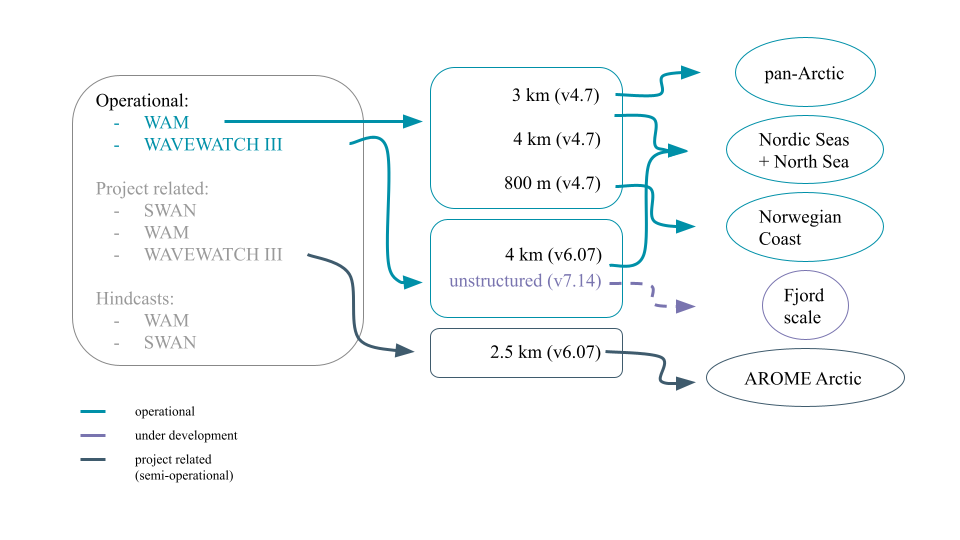
Forecast
WAVEWATCH III
MET Norway uses WAVEWATCHIII v6.07. The wave model is a third generation spectral wave model that computes the propagation of wave spectra. The model is phase averaging and does therefore not produce individual waves, but a statistical representation of the sea state resembling a superposition of multiple wave fields with different origin and characteristics (random phase/amplitude model). This characteristic is then propagated in space and time and evolves due to source and sink terms.
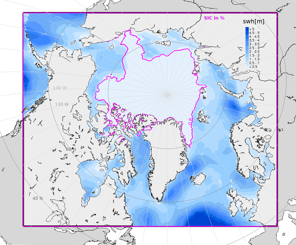
WAVEWATCHIII is forced with winds from ECMWF-IFS, sea-ice concentration from OSI SAF, and at the domain boundaries with spectra from the global ECWAM model from ECMWF. For testing, other forcing sources are added and can be activated. MET Norway provides 4xdaily prognosis with hourly output fields and a forecast length of 66 hours. The wave model grid has a horizontal resolution of 4km, and propagates the wave spectra with 36 frequencies and 36 directions. Wave model output can be obtained freely on THREDDS
WAM
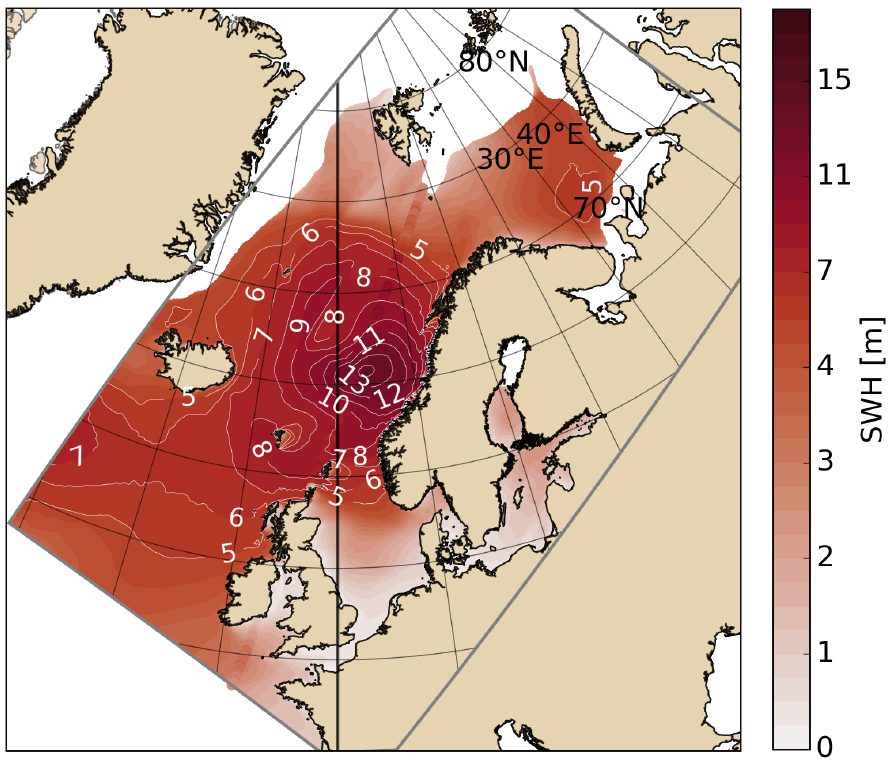
A pan-Arctic operational wave products is available at MET Norway throughout the European project ARC-MFC Copernicus. It use the wave spectral model WAM version Cycle 4.7 in the same domain as shown in the figure, with a horizontal resolution of 3 km. The forecast product is produced 2 times a day (at 00 and 12) with a 5 day and 10 day prediction into the future time length respectively. The model uses as forcing fields: surface winds (from ECMWF), surface ocean currents, sea ice concentration and sea ice thickness (from the forecast TOPAZ system). Products are available from the Copernicus Marine Service's catalog (registration required, access is free of charge).
Hindcast/Reanalysis
NORA10 (1957 - )
The NORA10 hindcast is produced by running an atmospheric downscaling of the ERA-40 reanalysis and wave hindcast covering the Norwegian Sea, the North Sea, and the Barents Sea (Reistad et al, 2011; Aarnes et al. 2012; Furevik and Haakenstad, 2012). The period covered is from September 1957 to 2022. The dynamic atmospheric downscaling is performed as a series of 9 hours prognostic runs initialized from a blend of ERA-40 and the previous prognostic run.
The nested WAM wave model hindcast consists of a coarse 50 km model covering the North Atlantic forced with ERA-40 winds and a nested 10–11 km resolution model forced with downscaled winds.
Data are available on request.
Reference:
Aarnes, O.J., Breivik, Ø. and Reistad, M. (2012) Wave extremes in the Northeast Atlantic. Journal of Climate, 25, 1529– 1543. https://doi.org/10.1175/JCLI-D-11-00132.1
Furevik, B.R. and Haakenstad, H. (2012) Near-surface marine wind profiles from rawinsonde and NORA10 hindcast. Journal of Geophysical Research, 117(D23), 14. https://doi.org/10.1029/2012JD018523
Reistad, M., Ø. Breivik, H. Haakenstad, O. J. Aarnes, B. R. Furevik, and J.‐R. Bidlot (2011), A high‐resolution hindcast of wind and waves for the North Sea, the Norwegian Sea, and the Barents Sea, J. Geophys. Res.,116, C05019, doi: https://doi.org/10.1029/2010JC006402
NORA3
The NORA3 atmospheric hindcast (NORA3_atmosphere) (Haakenstad et al., 2021; Haakenstad and ) is produced by running the non-hydrostatic HARMONIE-AROME model (Seity et al.,2011, Bengtsson et al.,2017, Muller et al.,2017) with 3km horizontal resolution and 65 vertical levels. The model runs 9 hourly forecasts four times a day. Each forecast starts from an assimilated state of the last forecast adapted to surface observations. Model levels are forced with ERA-5 (https://climate.copernicus.eu/climate-reanalysis).
The NORA3 wave hindcast (NORA3_wave) (Breivik et al., 2022) is produced by running the wave model WAM cycle 4.7.0 (Günther et al., 1992; Hasselmann et al., 1988; Komen et al., 1994) with wind forcing from NORA_atmosphere (HARMONIE-AROME Cy40h1.2 hindcast with 3km horizontal resolution), daily ice concentration fields from the ARC-MFC physical reanalysis system of the Copernicus Marine Service (CMEMS) and wave spectra from ERA-5 (https://climate.copernicus.eu/climate-reanalysis) at the boundaries. The WAM model was set up with 30 frequencies logarithmically spanning the range 0.0345–0.5476 Hz and 24 directional bins.
Data availability:
The data is available at: https://thredds.met.no/thredds/projects/nora3_subsets.html
NORA3_atmosphere:
- Data URL: https://thredds.met.no/thredds/dodsC/nora3_subset_atmos/atm_hourly/arome3km_1hr_<yyyymm>.nc (*replace <yyyymm> with year and month e.g. 202302)
- Mean sea level pressure
- Air temperature 2m
- Relative humidity 2m
- cloud_area_fraction for high, medium and low cloud types
- fog
- lifting condensation level
- wind speed and direction, 10m
- surface net longwave radiation and surface net shortwave radiation
- precipitation amount hourly
- Data URL: https://thredds.met.no/thredds/dodsC/nora3_subset_atmos/wind_hourly/arome3kmwind_1hr_<yyyymm>
.nc (*replace <yyyymm> with year and month e.g. 202302) - wind speed and direction in 10, 20, 50, 100, 250, 500, 750m height every hour
- Data URL: https://thredds.met.no/thredds/dodsC/nora3_subset_atmos/atm_v2/arome3km_3hr_<yyyymm> .nc (*replace <yyyymm> with year and month e.g. 202302)
- Air temperature in 50, 100, 150, 200, 300 m height every 3 hours
- Relative humidity in 50, 100, 150, 200, 300 m height every 3 hours
- Wind speed and direction in 50, 100, 150, 200, 300 m height every 3 hours
- Sea surface temperature every 3 hours (updated every 6 hours)
NORA3_wave:
- Data URL: https://thredds.met.no/thredds/dodsC/nora3_subset_wave/wave_tser/<yyyymm>
_NORA3wave_sub_time_unlimited.nc (*replace <yyyymm> with year and month e.g. 202302) - Permuted files for fast access to time series in single geographic locations
Reference:
Bengtsson, L., Andrae, U., Aspelien, T., Batrak, Y., Calvo, J., de Rooy, W., et al. (2017). The HARMONIE–AROME model configuration in the ALADIN–HIRLAM NWP system. Monthly Weather Review, 145(5), 1919–1935. https://doi.org/10.1175/MWR-D-16-0417.1
Breivik, Ø., Carrasco, A., Haakenstad, H., Aarnes, O. J., Behrens, A., Bidlot, J.-R., Björkqvist, J.-V., Bohlinger, P., Furevik, B. R., Staneva, J., and Reistad, M.(2022). The impact of a reduced high-wind Charnock parameter on wave growth with application to the North Sea, the Norwegian Sea, and the Arctic Ocean. Journal of Geophysical Research: Oceans, 127, e2021JC018196. https://doi.org/10.1029/2021JC018196
Günther, H., Hasselmann, S., & Janssen, P. A. E. M. (1992). Wamodel Cycle 4 (revised version) (tech. Rep. No. 4). Deutsches KlimaRechenZentrum.
Haakenstad, H., Breivik, Ø., Furevik, B., Reistad, M., Bohlinger, P., & Aarnes, O. J. (2021). NORA3: A nonhydrostatic high-resolution hindcast of the North Sea, the Norwegian Sea, and the Barents Sea. Journal of Applied Meteorology and Climatology. https://doi.org/10.1175/JAMC-D-21-0029.1
Haakenstad, H., & Breivik, Ø. (2022). NORA3. Part II: Precipitation and Temperature Statistics in Complex Terrain Modeled with a Nonhydrostatic Model, Journal of Applied Meteorology and Climatology, 61(10), 1549-1572. DOI: https://doi.org/10.1175/JAMC-D-22-0005.1
Hasselmann, S., Hasselmann, K., Bauer, E., Janssen, P. A. E. M., Komen, G. J., Bertotti, L., et al. (1988). The WAM model—A third generation ocean wave prediction model. Journal of Physical Oceanography, 18, 1775–1810. https://doi.org/10.10/bhs3rr
Komen, G. J., Cavaleri, L., Donelan, M., Hasselmann, K., Hasselmann, S., & Janssen, P. A. E. M. (1994). Dynamics and modelling of ocean waves. Cambridge University Press.
Müller, M., Y. Batrak, J. Kristiansen, M. A. Ø. Køltzow, and G. Noer, 2017a: Characteristics of a convective-scale weather forecasting system for the European Arctic. Mon. Wea. Rev., 145, 4771–4787, https://doi.org/10.1175/MWR-D-17-0194.1.
Müller, M., and Coauthors, 2017b: AROME-MetCoOp: A Nordic convective-scale operational weather prediction model. Wea. Forecasting, 32, 609–627, https://doi.org/10.1175/WAF-D-16-0099.1.
Seity, Y., Brousseau, P., Malardel, S., Hello, G., Bénard, P., Bouttier, F., et al. (2011). The AROME-France convective-scale operational model. Monthly Weather Review, 139(3), 976–991. https://doi.org/10.1175/2010MWR3425.1